Menu
Log in
Home
About Us
Who We Are
Public Policy Statements
Join Us
Renewals
Gift Memberships
Board of Directors
Illinois Forests
County Woodlands
Map 1820
Map 2000
Public Forests
Forest Types
Donate
Payment
Newsletters
Your Land
Boundaries
General Liability
Recreational Liability
Succession
Preserving the Family Forest
Ties to the Land
Ownership Tools
Endangered Species
Timber Sale Advice
Cost Share Programs
IDNR FDA
NRCS EQIP
Links
Organizations
Institutions
Publications
Forest/Tree Health Publications
Issues
Forestry Alerts
Law Alert
Health Alert
Disaster Alert
IDNR Reduction
Woodland Taxation
Fund Sweeps
Critical Issues
Off-Target Herbicide Drift
Non-Native Invasive Plants
Markets
Store
Consultant Directory
Sawmills
Forest Benefits
Product Directory
Timber Prices
Events
Videos
Remember me
Forgot password
Home
About Us
Who We Are
Public Policy Statements
Join Us
Renewals
Gift Memberships
Board of Directors
Illinois Forests
County Woodlands
Map 1820
Map 2000
Public Forests
Forest Types
Donate
Payment
Newsletters
Your Land
Boundaries
General Liability
Recreational Liability
Succession
Preserving the Family Forest
Ties to the Land
Ownership Tools
Endangered Species
Timber Sale Advice
Cost Share Programs
IDNR FDA
NRCS EQIP
Links
Organizations
Institutions
Publications
Forest/Tree Health Publications
Issues
Forestry Alerts
Law Alert
Health Alert
Disaster Alert
IDNR Reduction
Woodland Taxation
Fund Sweeps
Critical Issues
Off-Target Herbicide Drift
Non-Native Invasive Plants
Markets
Store
Consultant Directory
Sawmills
Forest Benefits
Product Directory
Timber Prices
Events
Videos
Log in
Join or Renew
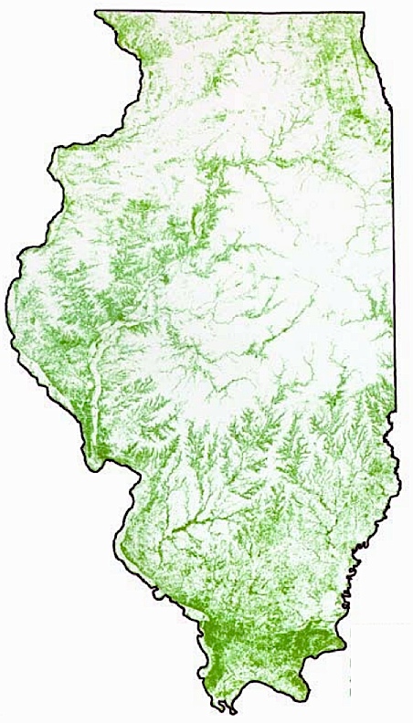
Illinois Forest Land Cover
The map below was produced by the USDA National Agricultural Statistical Service. It depicts forest cover for Illinois circa 2000.
© Illinois Forestry Association
HELP
FEEDBACK
All
photos not credited have been contributed
by IFA members
Powered by
Wild Apricot
Membership Software